New Map Reveals Strange Dent in the Magnetic Field Beneath Australia
Published Feb. 5 2026, 5:32 a.m. ET

CSIRO researchers describe a magnetic anomaly in the Northern Territory which resembles the shape of the Australian coastline.
Beneath Australia's Northern Territory lies a magnetic anomaly more complicated than previously assumed. Magnetic anomalies occur when the Earth's magnetic field twitches in a region due to magnetic properties embedded in rocks or iron core deposits in the crust. The Australia Magnetic Anomaly coincidentally resembles the country's coastline, but researchers believe there's more to it than meets the eye. A Commonwealth Scientific and Industrial Research Organisation (CSIRO) research team led by Dr. Clive Foss used high-resolution aeromagnetic data and sophisticated modelling techniques to look beyond the anomaly's outline and assess its dominance. The rocks and iron core in the Earth's crust formed "magnetic memories," or remanent magnetism, when they acquired magnetic properties, which can be used to trace their past.
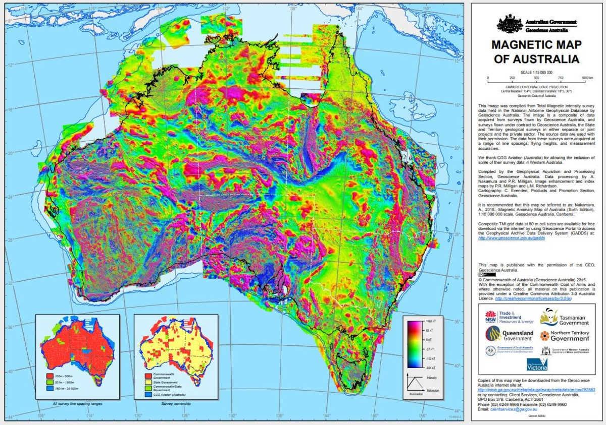
The magnetic anomaly map of Australia.
The research team was able to reconstruct the past of these rocks and other geological features that are overlooked in traditional mapping. That allowed them to determine when these hidden features imbued magnetism, giving a greater glimpse into the region's geological history. "Magnetic data allows us to see through the ground and understand geological architecture that would otherwise remain completely hidden," project lead Clive Foss, a senior research geoscientist with the CSIRO, said in a statement. “By improving how we process and model these datasets, we can extract more geological information than ever before," he added. While usual surface mapping is efficient, it may overlook tiny cracks and folds in the magnetic field caused by the magnetic field of the minerals present within the planet's crust. Reconstructing the past of these magnetic minerals will allow scientists to track even the tiniest changes in Earth's magnetic field.
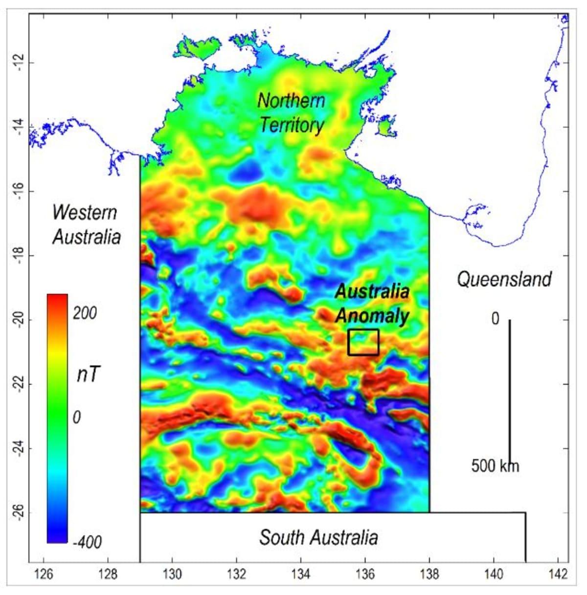
The Australia Magnetic Anomaly
In Australia's Northern Territory, intense weathering often conceals what actually lies beneath the surface. That's where these magnetic surveys serve their purpose by looking beyond the obscurations in the subsurface and seeing through our planet more effectively. The recent Australia Magnetic Anomaly mapping was done using regional aeromagnetic data gathered during the Northern Territory Government’s Bonney Well Survey. The open-access data acted as a base for CSIRO to conduct further magnetic mapping. The recent survey showed clearer results, unlike the previous maps that blurred certain details, especially when the magnetic structure and flightlines are aligned with one another. “My colleague, Dr Aaron Davis, created an innovative gridding algorithm, which refined the dataset and produced cleaner, more consistent images,” Dr. Foss said.

Aircraft fitted with magnetometers to scan the landscape
The result of the modified study was a eureka moment for the researchers. They were able to witness defined geological boundaries, subtle magnetic layers, and magnetic signatures that previously went unnoticed. While most of the Australian Magnetic Anomaly is buried, surface outcrops can be found along its western edge. Although in tiny traces, these surface outcrops provide information about the area's geological past. The outcrops found in the Paleoproterozoic Hatches Creek Formation have sandstones, originally laid out in shallow seas and river deltas. Over time, these formations have constantly changed shape and folded, leaving behind a complex subsurface structure.
Through modern and advanced mapping, scientists are now unraveling such hidden subsurface structures that influenced the Earth's magnetic field. “Estimating the depth of the anomaly’s source and deciphering the direction of magnetization can be complicated by remanent signatures preserved since the rocks formed,” Dr. Foss said. “Australia's shifting tectonic position, combined with periodic reversals of Earth's magnetic field, means that remanent magnetization often points in unexpected directions, demanding expert interpretation," he added.