This Nor'Easter Looks Beautiful From Space. On the Ground, It's Turning Dangerous Fast
Published Feb. 24 2026, 8:01 a.m. ET

A stunning satellite shot of a powerful nor'easter.
From space, the storm looks scenic, something out of a fantasy, but beneath the swirling white giant stretching over the northeastern United States lies a dangerous reality. The famously powerful nor’easter winter storm is sweeping across the country, putting over 60 million residents under winter storm warnings. The situation on the ground is quite chaotic, but the recent satellite photos are a visual treat. The storm is named after the direction in which its strongest wind typically flows, according to NOAA. It originates about 100 miles off the coast in the middle of New Jersey and Georgia, deemed as the "perfect" spot for storms to form.
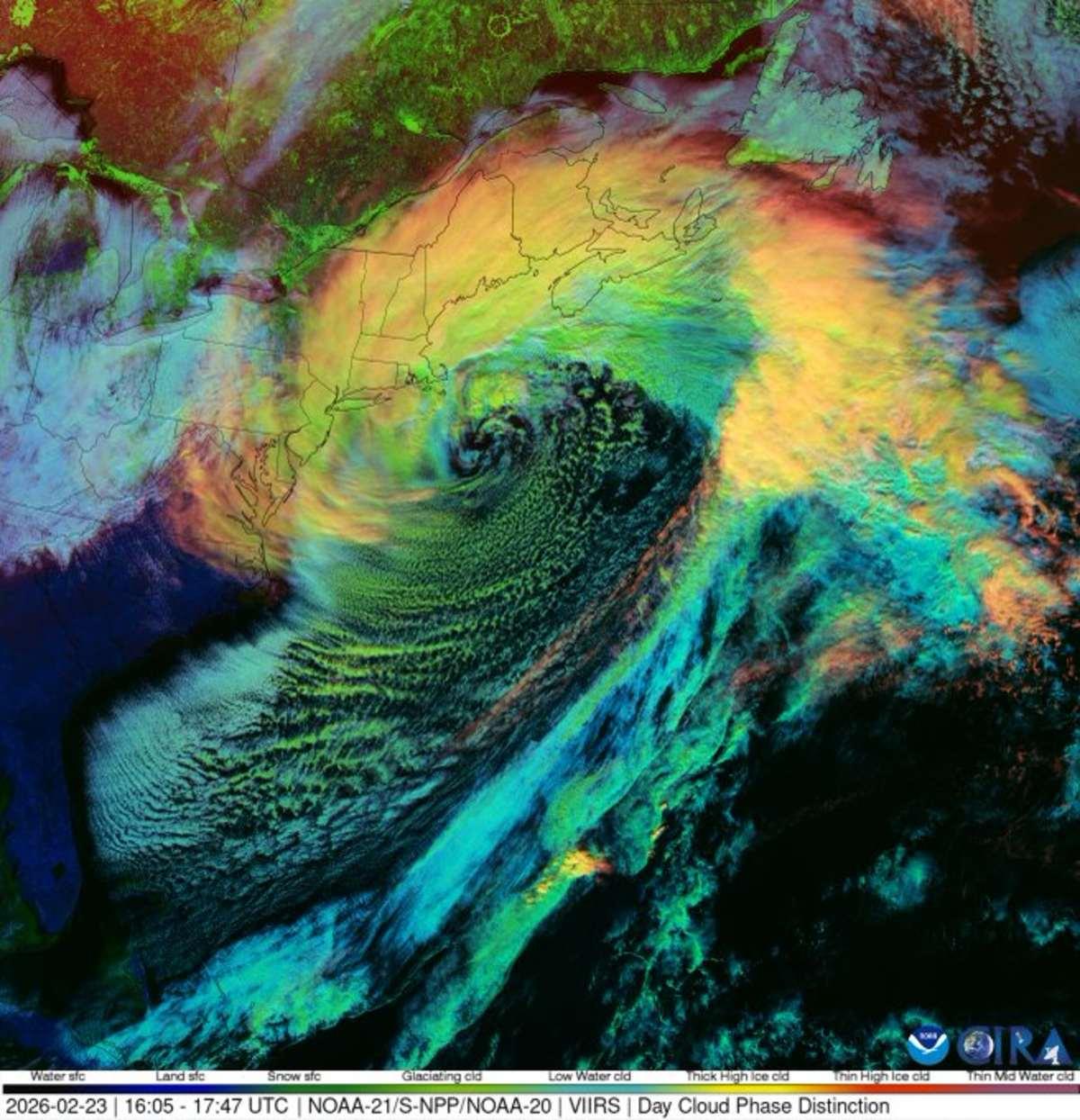
A view of the dynamic nor'easter swirling just off the East Coast.
“The polar jet stream blows cold air southward out of Canada and eastward toward the ocean. The Atlantic Ocean is warm, thanks to the Gulf Stream–a warm ocean current," the agency added. When the cold air meets the warm ocean, it triggers low-pressure storms to form that eventually grow larger and more powerful. The recent satellite images, at first glance, would appear no different than a regular giant swirling storm, but NOAA insists there's some distinction. The major difference is in the place the storm occurred. Spiraling storms are massive and cover vast stretches of land and can be formed in various places, whereas the nor’easter winter storm originates much further south and over the Atlantic Ocean.
Both are similar in terms of being cyclones rotating around an eye, which is a low-pressure region. But many things set the nor'easter storm apart from the other storms, including being fueled by warm winds in contrast to the cold winds that other storms require. The nor’easter storm can be quite powerful and destructive to nature. “If you hear that a nor’easter is headed your way, prepare for very bad weather," NOAA says. "Nor’easters can produce heavy snow and blizzards, rain and flooding, and huge crashing waves. These waves can cause erosion to the beach and severe damage to nearby buildings and structures. Nor’easters can also produce wind gusts that are even stronger than hurricane-force winds," NOAA added.
Meteorologist Ryan Maue posted pictures of the stunning satellite images of the storm that was recently captured. "Morning satellite imagery shows the 'swirling eye' of powerful 'bomb cyclone' off the US East Coast ... New Jersey. Functionally a hurricane," he captioned the post. Maue revealed that the storm was moving at the speed of 90 mph with a pressure of 972 mb. Some parts of the country have been experiencing the impact of the powerful storm that's moving along the Northeast coast.
"This is the first blizzard for much of the mid-Atlantic and southern New England coasts in about four years," said AccuWeather Senior Meteorologist Tyler Roys. "In much of southeastern New England, this storm will rival the infamous Blizzard of '78 in terms of intensity and snowfall," he revealed. "For New York City, the last time there was a blizzard warning in effect was during the storm from Feb. 8-9, 2017," AccuWeather Senior Meteorologist Chad Merrill said. Philadelphia also experienced its biggest single snowfall event since 2016. On Monday, February 23, the region witnessed 14 inches of storm, as per the outlet.