NOAA Satellites Capture Florida’s Wildfire Expand from 5,000 to 25,000 Acres in Everglades
Published Feb. 25 2026, 9:40 a.m. ET

Wildfire capture by NOAA satellite
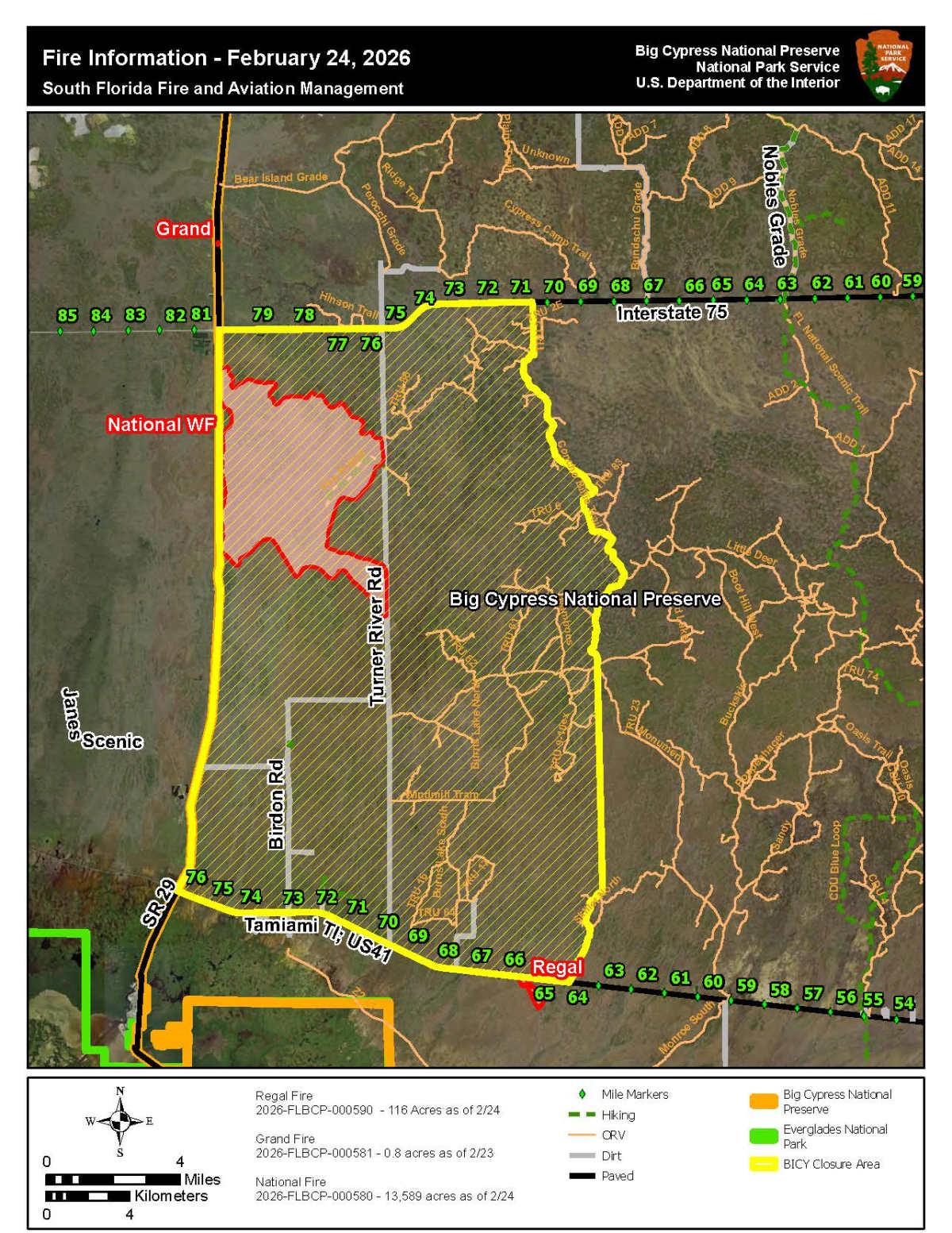
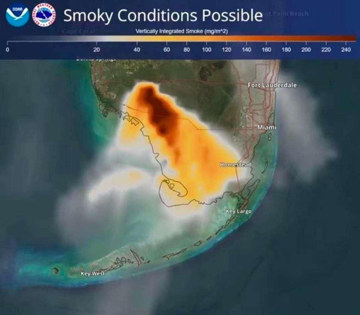
A South Florida Wildfire has magnified in size, after it was first discovered on February 22, 2026, within the Big Cypress National Preserve in the Everglades, according to Fox Weather. It has been labeled “The National Wildfire” and was initially spread across 5,000 acres. Satellite footage from the National Oceanic and Atmospheric Administration (NOAA) displays that within a few days, the wildfire has increased in severity and range. It has now spread across 25,000 acres and can also be spotted from space. The smoke plume and heat from the wildfire’s blaze are being tracked by NOAA’s GOES East (GOES-19) satellite.
The National Weather Service Miami-South Florida has warned residents that they may encounter visibility issues due to dense smoke from the wildfire. Aviation crews quickly set out after the wildfire’s discovery to suppress the flames and prevent damage. Experts claim the fire behavior will continue to intensify in the coming days. Burn bans have been issued in Collier, Palm Beach, Hendry, and Glades counties to control the situation.
South Florida Wildfire Update
Officials added that dry air and surface winds will support the flames. "Wind fields in the vicinity of wildland fires can be highly variable or turbulent, exhibiting significant gusts that can lead to erratic fire behavior and enhanced mixing of smoke into the atmosphere," explained the U.S. Department of Agriculture Forest Service. There is no immediate threat to civilians, but if the fire continues to extend, the situation may change.
Two fires constituted this wildfire. One was located north of Interstate-75, and another was detected south of I-75 and east of State Road 29, according to the National Park Service (NPS). Considering the wildfire’s location, behavior, and weather conditions, fire managers decided to implement closures in regions south of I-75, east of SR 29, north of HWY 41, and west of TRU 2, Concho Billie Trail, and Skillet North. Residents in the closure areas have been instructed to be in a “ready” state and monitor the situation through Big Cypress National Preserve web alerts at Alerts & Conditions - Big Cypress National Preserve (U.S. National Park Service) - and local media. The wildfire was allegedly man-made, according to Airnow. gov.
National Wildfire on satellite image
The Florida Forest Service (FFS) states that the wildfire is 0% contained, according to Gulf Coast News. Officials are concerned due to the wildfire’s proximity to Alligator Alley, a major route for drivers. The fire is blocking a lane on Interstate 75 in Collier County. The National Weather Service has warned of visibility issues until 9 am in Jerome, Big Cypress, Copeland, Ochopee, Everglades City, and along the Tamiami Trail. Firefighters from various agencies are involved in suppressing the wildfire. They are employing a method called back burning to prevent the grass from burning.
Riki Hoopes, a spokesperson for the combined state and federal firefighting agencies, said that no structures or firefighters have been injured to this date, according to WGCU News. "It’s an exceptionally dry year. We haven’t had any precipitation in months, so it’s not unusual to see fires spread in a couple year’s growth like that," she shared. Experts suggest that smoke from the "National Wildfire" is making its way to the Keys, according to Keys News. The wildfire has already ravaged a huge portion of land in the Big Cypress Swamp and Everglades.