Mysterious Plumes Created Underwater Canyon in the Atlantic That’s Bigger than the Grand Canyon
Published Feb. 25 2026, 7:23 a.m. ET

Bathymetric map of the King’s Trough complex with associated deep basins at its eastern end (Peake and Freen Deeps) based on new bathymetric data combined from GEOMAR cruise M168 and Portuguese cruise EMEPC/PEPC/LUSO/2013
About 620 miles off the coast of Portugal, the rolling waves of the North Atlantic hide a mystery underneath that goes back millions of years in time. Spread out across 310 miles, this gigantic underwater structure looks like the carcass of a forgotten kingdom, aptly named King’s Trough Complex, or KTC. Skyscraper-like walls skirt along parallel trenches, punctuated by deep basins and flanking ridges that resemble broken teeth or cigarette stubs. In a study published in AGU’s Geochemistry, Geophysics, Geosystems, scientists documented the fascinating story that plotted the spectacular formation of this structure, nicknaming it the “Grand Canyon of the Atlantic.” Dozens of millions of years ago, the crust of the seafloor heaved open like a giant zipper and sculpted this remarkable geometry.
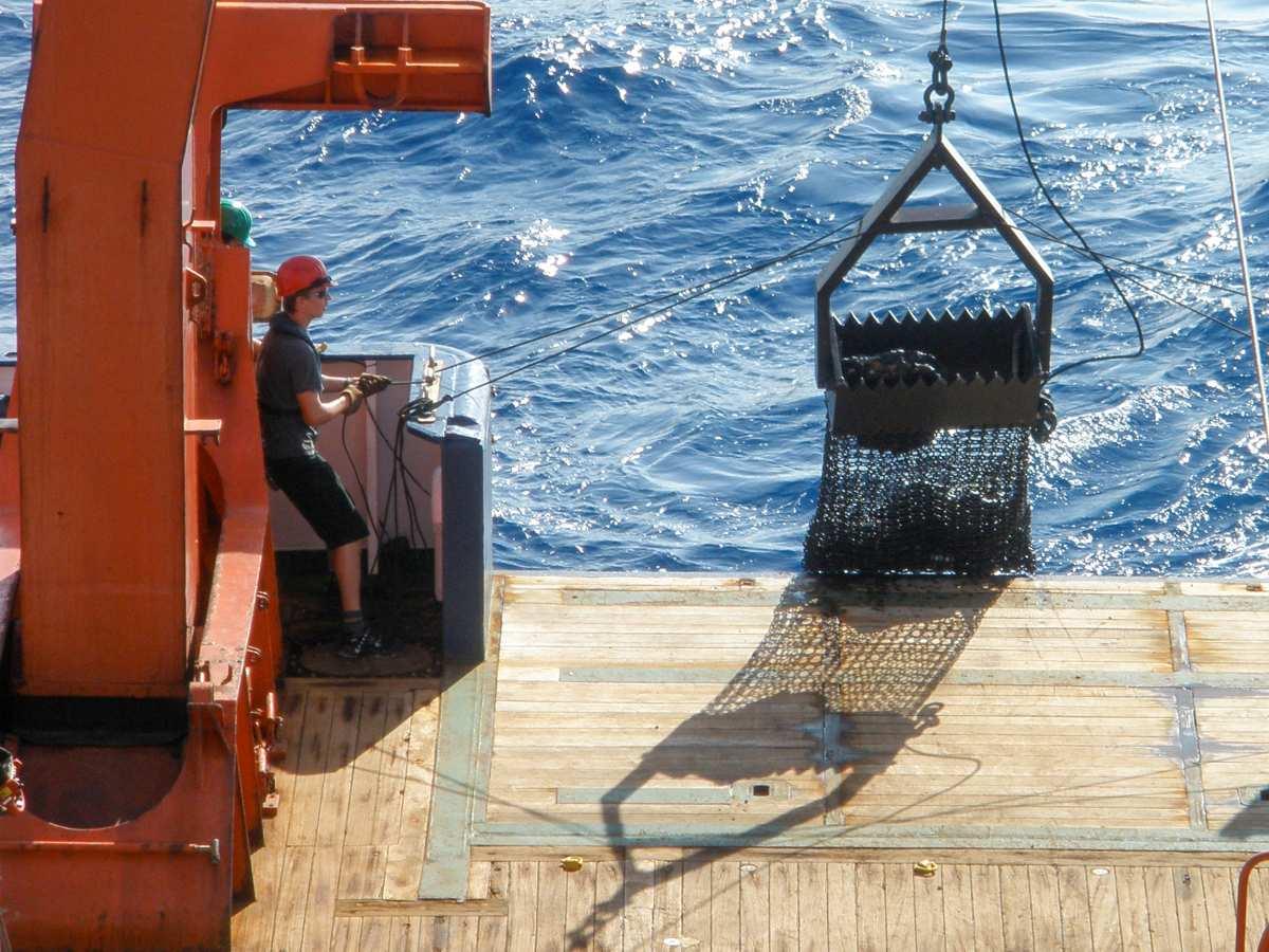
The chain bag dredge is brought back on board. It can be used to collect specific rock samples from depths of several thousand meters
On land, mountains and canyons are created by rivers that rush and course through sediment trails, grinding rocks and carving depressions like these. Under the water, however, no similar or comparable process has been recorded. All those underwater mountains, or marine canyons, are thought to have formed due to disturbances in the seafloor. But when Dr. Antje Dürkefälden, a marine geologist at Helmholtz Centre for Ocean Research Kiel (GEOMAR) investigated KTC, an entirely unexpected sequence of events emerged, something she or her colleagues had never observed before.
KTC is a vast body stitched together with a mosaic of assorted geometrical structures. The eastern lip of this body is fringed by Peake Deep, one of the deepest locations in the Atlantic Ocean. The southeastern limb merges with Freen Deep. Separated by Palmer Ridge, the two basins cradle this magnificent architecture that left scientists like Dürkefälden mystified and curious.
For years, scientists believed that the structure was a result of simple seafloor stretching. But when Dürkefälden’s team plucked some rocks from the magnetic fabric of the canyon, they realized that this wasn't how KTC formed. Contrary to their hypothesis, they found that a whole lot of plate tectonics was there in the background.
Plate tectonics relates to the shifting movements of Earth’s crust that shape everything from mountains to canyons and even basins. Long ago, when humans were not yet separated by continents and countries, the land was a huge piece of unbroken crust. Then the big piece cracked and fragmented into several smaller pieces, resulting in the formation of the continents that exist in the present day. One of these violent plate performances became the initiation point for KTC’s formation.
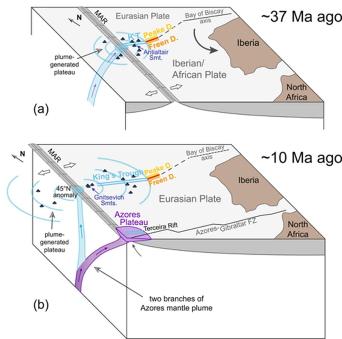
Cartoon showing the eastern North Atlantic region at ∼37 Ma after the plate boundary had just jumped to the King's Trough Complex area, resulting in oblique extension beginning at the Peake and Freen Deeps due to the continued anticlockwise rotation of the Iberian/African plate
Between 24 and 37 million years ago, the plate boundary between Europe and Africa temporarily passed through the North Atlantic. At one point, the crust pulled apart, got fractured, and started opening up “like a zipper being undone,” as scientists described in the study. Scientists concluded that long before this rampage of plate boundaries occurred, the crust was being slowly preconditioned for this event by the mantle.
Before the plate boundary jumped south, the ocean crust was already thickened and heated by the hot magmatic material rising from deep within the simmering mantle. Once the lava cooled down, the rifting stopped, and canyons were frozen in time with fresh lava varnishing their basin walls. Scientists had collected the rocks from KTC during the 2020 expedition M168 aboard the vessel METEOR. The expedition deployed high-resolution echo-sounding sonars that produced a detailed map of the seafloor that recorded several fan-shaped echoes. Using chain bag dredges, they also retrieved samples of volcanic rock, glass, and lava from the southwestern flank and other portions of KTC. Back in the laboratory, they stripped the rocks and extracted their chemical fingerprints.
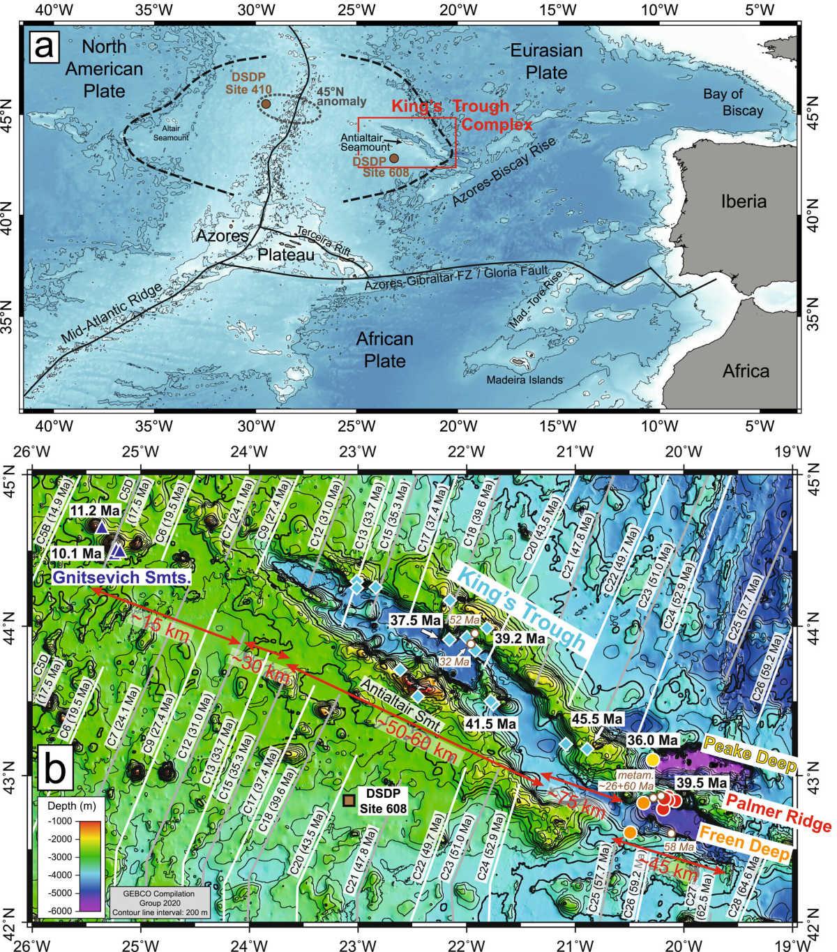
Overview map of the eastern North Atlantic with a red frame indicating the location of the King's Trough Complex northeast of the Azores Plateau
Argon dating, a clock based on radioactive decay to read ages, was used to deduce their ages. Bathymetric data, which tells information about underwater terrains and water depths, was fetched from a Portuguese research center. Plate-kinematic modelling was used to travel back in time and document the complex drama that happened between the two tectonic plates.